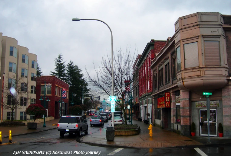
Auburn, Washington's downtown. AJM STUDIOS Northwest Photo Journey photo.
Auburn is a city in King and Pierce counties (primarily in King). The population was 40,314 at the 2000 census; the State of Washington Office of Financial Management estimates the City of Auburn's population to be 67,485 as of April 1, 2008. The population increased dramatically resulting from the recent annexations of the West Hill, and Lea Hill, Washington communities directly east and west of the city.
The town was named Auburn on February 21, 1893, before either Seattle or Tacoma had suburbs, Auburn is now generally considered a suburb in the Seattle-Tacoma-Bellevue metropolitan area. Auburn is currently ranked the 13th largest city in the state of Washington. Auburn is roughly bordered by the cities of Federal Way, Pacific, and Algona to the west, Sumner to the south, unincorporated King County to the east, and Kent to the north. The Muckleshoot Indian Reservation is located within city limits.
History
Auburn was originally incorporated as Slaughter, Washington after Lt. William Slaughter, who died in an Indian skirmish in 1855. At the time, the main hotel in town was called the "Slaughter House." In 1893, a large group of settlers from Auburn, New York moved to Slaughter, and renamed the town to "Auburn." Due to this history, when Auburn was building its second high school in the mid-1990s, there was a grass-roots effort to name the high school "Slaughter High School," but it was eventually decided that the name would be too politically incorrect, and the High School was named "Auburn Riverside High School," whose mascot is the Ravens. There are several locations in Auburn on the National and State Registers of Historic Places, such as the Neely Mansion.
The city of Auburn, located 20 miles south of Seattle, was home to some of the earliest settlers in King County. Nestled in a fertile river valley, Auburn has been both a farm community and a center of business and industry for more than 150 years. Auburn is located near the original confluence of the Green and White rivers, both of which contain runoff water from the Cascade Mountain range. The valley was originally the home of the Skopamish, Smalhkamish, and Stkamish Indian tribes. The first white men in the region were explorers and traders who arrived in the 1830s.
Settlers first came to the valley in the 1850s. On October 27, 1855, an Indian ambush killed nine people, including women and children. In November, a military unit led by Lieutenant William Slaughter camped near what is now present-day Auburn. On December 4, 1855, a group of Indians attacked, killing Lt. Slaughter and two other men.
A new treaty was written which provided the establishment of the Muckleshoot reservation, which is the only Indian reservation now within the boundaries of King County. The White River tribes collectively became known as the Muckleshoot tribe. White settlers, the Neely and Ballard families began returning to the area. In 1891, the town of Slaughter incorporated. Although many older citizens considered the town's name as a memorial, many newer residents understandably felt uncomfortable with it. Within two years, the town was renamed Auburn, taken from the first line of Oliver Goldsmith's poem, The Deserted Village: "Sweet Auburn! Loveliest village of the plain."
Auburn had been a bustling center for hop farming until 1890 when the crops were destroyed by aphids. After that, the farms were mostly dairy farms and berry farms. Nevertheless, flooding was still a problem for Auburn farmers up until the Howard A. Hanson Dam was built in 1962. This dam on the Green River, along with the Mud Mountain Dam on the White River, provided controlled river management, which left the valley nearly flood-free.
Another impetus to Auburn's growth was the railroad. The Northern Pacific Railroad put a rail line through town in 1883, but it was the Seattle-Tacoma Interurban line that allowed easy access to both cities starting in 1902. The Interurban allowed farmers to get their product to the markets within hours after harvest. The railroad, along with better roads, caused many new companies to set up business in Auburn, among them the Borden Condensery (which made Borden's Condensed Milk) and the Northern Clay Company.
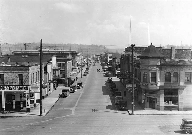
Downtown Auburn, WA in 1930.
Auburn grew through the twentieth century like many American towns. The 1920s were prosperous for citizens, but the Great Depression of the 1930s left many in need. World War II brought great hardship to many local Japanese farmers when they were moved to internment camps and their land taken from them. At the same time, local boys were sent to fight in the Pacific, and some died in battle.
The postwar era was prosperous to Auburn, bringing more businesses and a community college to the city. In 1963, The Boeing Company built a large facility to mill sheet metal skin for jet airliners. As time went on, many farms disappeared as the land was converted to industrial use. In 1995, The Supermall of the Great Northwest was built in the valley, enticing consumers from all over the Puget Sound region.
Auburn has made the transition from small farms to large industries, but much of the city's history remains. A monument in the memory of Lieutenant Slaughter, erected in 1918, still stands in a local park. The Neely Mansion, built by the son of a pioneer in 1891, has been refurbished and is listed on the National Register of Historic Places. Auburn's downtown still maintains a "Main Street U.S.A" appearance.
Geography
Auburn is located at 47°18′8″N 122°12′53″W (47.302322, -122.214779).
According to the United States Census Bureau, the city has a total area of 21.3 mi² and of it is land and 0.05% is water.
Two rivers, the White River and, to a greater extent, the Green River flow through Auburn. Historically, the Stuck River ran through the settlement of Stuck, which is now a small pocket of unincorporated King County within southern Auburn. In 1906, the flow of the White River was diverted into the Stuck's channel near today's Game Farm Park. References to the Stuck River still appear in some property legal descriptions and place names, e.g. Stuck River Drive, within Auburn, but today it is essentially indistinguishable from the southern White River.
Districts and their Neighborhoods
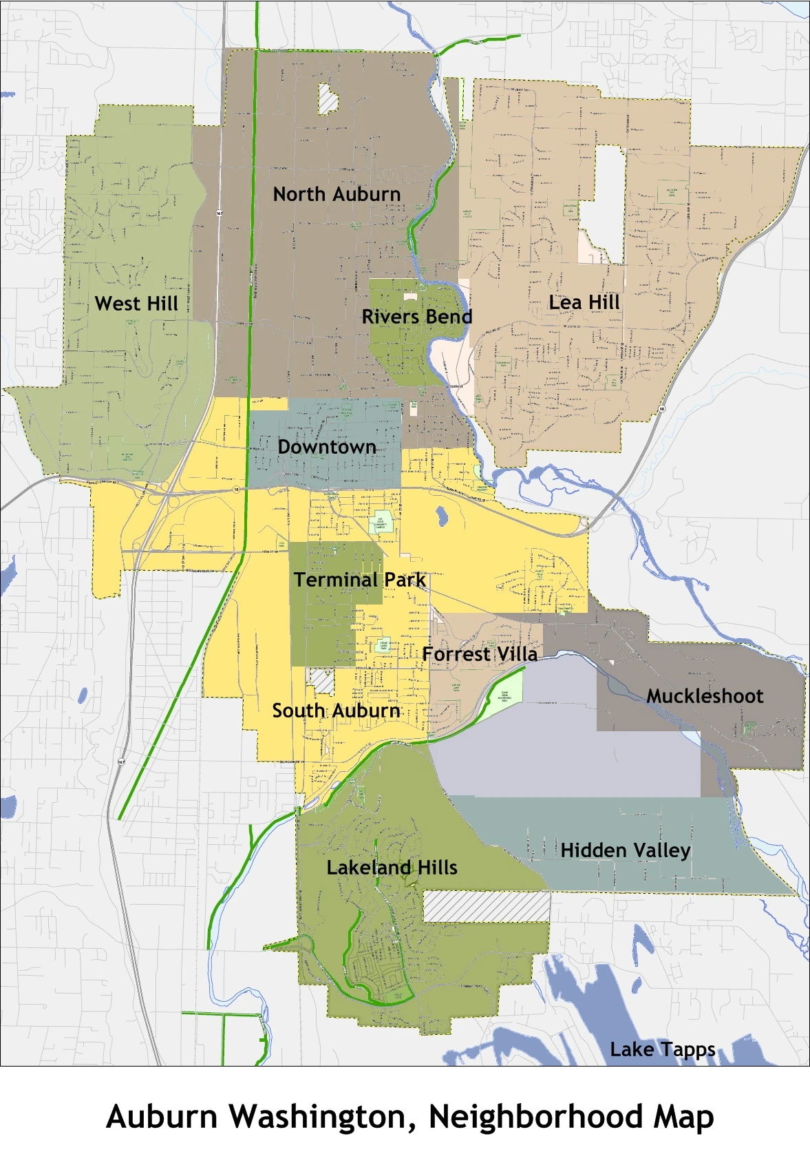
Neighborhood map for Auburn.
- Downtown - Historic buildings with a Main Street 'USA' appearance, also many Craftsman style houses from the 1920s.
- North Auburn - A mix of commercial and single family housing separated by Auburn Way North.
- River's Bend - Residential neighborhood adjacent to the Green River, located at the bottom of Lea Hill in North Auburn.
- Christopher/Thomas - An area in North Auburn Roughly Bordered by the Valley Drive Inn, and 227th. Both former farming towns eventually annexed into the city in the 1960s.
- Lea Hill, Washington - A mainly residential neighborhood east of the valley, annexed into the city in 2007. Green River Community College is located here.
- Hazelwood - the general area on Lea Hill between Green River Community College, and Auburn Mountainview High School. Once a town in the late 1800s.
- West Valley - A commercial and industrial area on the west side of SR 167, located on the bottom of West Hill.
- West Hill - An affluent neighborhood located on the West Hill, bordered by the city of Federal Way to the west.
- South Auburn - A general area located south of Downtown, once a low-income area but quickly becoming a commercial zone.
- Terminal Park - An 'up-and-coming' area of middle class housing near the end of the train yard named for the railroad workers who lived there.
- Forest Villa - Mainly residential area located in the Game Farm Park area, an affluent neighborhood from the 1970s - Present.
- Lakeland Hills - A master-planned affluent community sprawling on a large hillside at the southern end of the city on both sides of King and Pierce Counties.
- Hidden Valley - A planned development located East of Lakeland Hills overlooking North Lake Tapps.
- Muckleshoot Area - The general area of the Muckleshoot|Muckleshoot Indian Reservation .
Culture
Media
Newspapers
Auburn Reporter
Infrastructure
Downtown Redevelopment

Auburn's downtown. AJM STUDIOS Northwest Photo Journey photo.
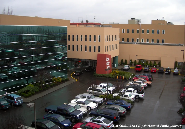
Beginning in the late 1970s Auburn's downtown began a slow decline in business and travel. A 2001 citizens plan gathered ideals and realizations of the citizens of Auburn and what they wanted in downtown, after several years development has begun. In 2008 construction began of a new 300 hundred stall, 97,000-square-foot parking garage and medical building for the Auburn Regional Medical Center, located directly north of city hall.
With the garage now being built, now parking opportunity have allowed city code to continue with the re-development of the downtown core. In 2009 a city annex and a Key Bank Branch anchored to the east will sit on the current site of the abandoned tavern row. With the main project goal of encompassing a regional entertainment and shopping center, while being an Urban Center. The “Auburn Junction” will complete that goal. Proposed and adopted by the city council Alpert International will begin construction in 2010 with 750,000 square feet, and a price tag of $240,000,000, the Junction will include retail below and high density apartments/condos above.An AMC theatre, and traditional court yard will be included. It will cover the main block on the former Cavanaugh site. In addition to the Auburn Junction, the Stratford company will construct a 200-unit mixed use development called Auburn Station I & II, set for construction in late 2009. It will be located in the heart of downtown adjacent to the Auburn Sounder Station. With the redevelopment occurring at fast rate, projections are that downtown in the next 15 years will once again become vital and vibrant while enticing all, throughout the lower Puget sound area.
Health systems

Auburn Regional Medical Center. AJM STUDIOS Northwest Photo Journey photo.
Auburn has one major hospital. The Auburn Regional Medical Center is located in downtown. (202 N DIVISION / PLAZA ONE)
Transportation

Auburn Station. AJM STUDIOS Northwest Photo Journey photo.
Auburn has many large roads nearby and within city limits, including SR 167 commonly referred as the "Valley Freeway", and SR 18. Auburn also has its own Transit Center, Auburn (Sounder station) in downtown, making it a central gateway key to access with Sound Transit to the entire Puget Sound area, and was up until the mid 60’s home to Northern Pacific's, (now Burlington Northern Santa Fe) central roundhouse. In addition, the Auburn Municipal Airport serves the general aviation community.