Asotin County is a county located in Washington . It is part of the Lewiston, ID-WA Metropolitan Statistical Area, which includes all of both Nez Perce County, Idaho, and Asotin County. As of 2000, the population was 20,551. The county seat is at Asotin, and its largest city is Clarkston.
"Asotin" derives from a Nez Perce word meaning "Eel Creek".
Asotin County was created out of Garfield County on October 27, 1883.
History[]
The Nez Perce tribes lived in Asotin County for many years before Lewis and Clark arrived in 1805. The word Asotin comes from the Nez Perce word for eel, Has-shu-tin, so named because of the eel that abounded in Asotin Creek. Though indigenous to southeastern Washington as well as east into Idaho, the tribes lived a rather nomadic life and every season trekked across the Rockies on the Nez Perce Trail to hunt buffalo in the Great Plains. The Nez Perce Trail extended east from the Columbia River at the present-day town of Wallula in Walla Walla County through Garfield and Asotin counties, crossing the Snake River at the Red Wolf Crossing below Silcott, about seven miles west of present day (2006) Clarkston, Washington, and then continuing east across the Rockies to the Great Plains.
Lewis and Clark passed through the county on their expedition, both outbound to the Pacific Ocean in 1805, and on their return trip to Missouri in 1806. The Expedition camped at the Nez Perce village of Alpowa (near today's Chief Timothy State Park) on October 11, 1805, and again on May 4, 1806.
Captain B. L. E. Bonneville led the next major expedition through Asotin County in February 1834, surveying the region on behalf of the United States government (which declined to pay him for his efforts) and spending several weeks with Native American tribes in their tribal villages, first in the southern part of the county on the Grande Ronde River, then farther north on the Snake River.
Whites made a few tentative settlements in Asotin County during the 1860s. The first settler, Sam Smith, arrived near the confluence of Alpowa Creek and the Snake River on June 10, 1861, and opened a small store and hotel for travelers on their way to and from the Orofino gold mines in Idaho. However, Smith didn't stay long, and for much of the 1860s, the only activity in the county was from gold prospectors, who found little gold. In the late 1860s, a few more permanent homes were built, mostly along Asotin Creek and in or near what would later become Asotin.
In 1877, a number of settlers arrived and built cabins on Asotin Flat near present day Anatone. By the end of the 1870s contemporary accounts put the population of the area between Anatone and Asotin between 200 and 400.
Anatone established its first business in 1878 and was an early important trading post, but the town itself was not platted until 1901. Although Anatone is the third largest town in Asotin County, its population over the years appears to have never exceeded 100 or so people; a sign at the edge of town in 2003 read "45 people, 27 cats, 22 dogs and 21 horses"
Eighteen miles north of Anatone, Assotin City was platted in 1880. There were actually two Asotins in the early years: Assotin City, located on the southern end of present day [[Asotin], and the town of Asotin, just to the north, on the southern flank of Asotin Creek. Asotin was platted in 1881 and by 1883 had outgrown its rival to the south; in February 1886, Assotin City changed its name to Asotin and within a year the merger was complete.
Asotin County was formed from the eastern portion of Garfield County in 1883. On October 20, 1883, the Washington Territorial Legislature voted to create Asotin County, and Territorial Governor William Newell (1817-1901) approved the law on October 27. Asotin County "officially" came into being on November 12, 1883.
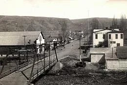
Downtown Asotin in the 1920's.
Asotin grew steadily during the 1880s and 1890s. Wheat and later barley were early crops, followed by cattle farming. Plum, peach, and especially apple orchards were also planted and actively maintained.
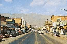
Downtown Clarkston, 1950's.
Asotin County's growth was assured in 1896 by the construction of an 18-mile-long irrigation canal running from Asotin Creek above Asotin to Jawbone Flat, an area of potentially fertile -- but at that time barren -- land along the Snake River in and to the west of present-day (2006) Clarkston. On July 18, 1896, the canal began providing water to Jawbone Flat, and the effect it had on the area was remarkable: Population of the area that would soon become Clarkston boomed from perhaps 15 people in 1896 to approximately 2,200 in the Clarkston-Vineland area in 1903. (Vineland, a community just west of Clarkston, merged with Clarkston shortly after 1903).
Clarkston's growth was further aided by the opening of the Lewiston-Clarkston Bridge on June 24, 1899, which connected Clarkston to Lewiston, Idaho. The first Clarkston settlers wanted to name the new town Lewiston, and applied for a post office with that name. The United States Postal Department rejected the request, reasoning that Lewiston, Washington, would cause too much confusion with Lewiston, Idaho, just across the Snake River. Thus in 1897 the town was officially named Concord (after Concord, Massachusetts), but by 1900 the post office had changed its name to Clarkston. In 1901 the legislature made the name change official, and Clarkston was incorporated on August 4, 1902.
The irrigation of Jawbone Flat and the subsequent rapid growth in the early years of the twentieth century of a wide variety of fruit and berry orchards and vegetable farms in this newly irrigated region had a profound effect on Asotin County. Whereas during the last two decades of the nineteenth century most of the county's growth had been in or near the town of Asotin, Asotin and Anatone both peaked in their population growth shortly after 1900 and -- with some fluctuations -- both towns have remained relatively stationary in population since, with Asotin averaging near 1,000 and Anatone about 100. Clarkston meanwhile quickly grew to a population of 6,209 in 1960 and 7,337 in 2000.
Agriculture continued to dominate Asotin County's economy through the 1950s. Thanks to the irrigation of Jawbone Flat, a wide variety of produce and fruit was grown in the regions west of Clarkston along the Snake River. Abundant meat and dairy farms complemented vegetable and grain farms and orchards.
From the early days of settlement on the Snake River, people had talked of opening the river to make it navigable all the way to the Pacific Ocean. Finally in 1945 Congress authorized the Lower Snake River Project. Beginning in the early 1960s the project began to take shape with the construction of four dams along the Snake River in Washington state. Asotin County was affected by the construction of the final dam, the Lower Granite Dam. Construction on the dam began in July 1965.
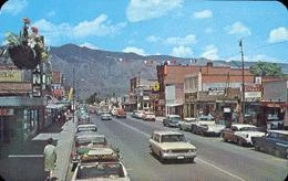
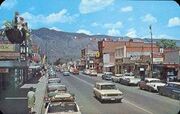
Clarkston, Washington, 1960's.
Though the Lower Granite Dam bridges Whitman and Garfield counties, it has had far reaching impacts on Asotin County. It created a large lake, the 39-mile-long Lower Granite Lake, which reaches into Asotin County. Preparation for filling the lake took more than two years after the Lower Granite Dam was completed before the lake was allowed to begin filling on February 15, 1975. In the meantime, a new port was built on the Snake River at Clarkston (the second farthest-inland port in the United States), which was dedicated on June 20, 1975.
Although Clarkston is actually the smallest of a trio of area ports, which include ports in Lewiston and Wilma (Whitman County), the port has brought an incalculable economic boost to Clarkston since 1975, adding a new dimension to life in Asotin County.
Geography[]
According to the U.S. Census Bureau, the county has a total area of 641 square miles (1,659 km²), of which, 635 square miles (1,646 km²) of it is land and 5 square miles (14 km²) of it (0.83%) is water. It is part of the Palouse, a wide and rolling prairie-like region of the middle Columbia basin.
At 636 square miles, Asotin County is the sixth-smallest county in the state. It has a fertile agricultural region in the north-central region, while farther south, the terrain becomes more rugged and is marked by creeks and gullies. Elevations dip to as low as 740 feet in the northeastern corner near Clarkston, and rise to exceed 6,000 feet in the extreme southwestern region in the Blue Mountains. Asotin County's history has been primarily an agricultural one centered on farming and fruit orchards.
Politics[]
Generally, Asotin County is considered a staunchly Republican area, although it has been known to vote for Democrats, especially on the state level. Currently the county is represented at the county level by two Democrats and one Republican.
In the 2004 Presidential election gave slightly over 60 percent of the vote to Republican George W. Bush. It was one of 11 of Washington's 39 counties where Bush received a lower percentage of the vote in 2004 than in 2000. Conversely, even though nearly 60 percent of voters selected the Democratic Governor Gary Locke in 2000, in 2004 the Democratic gubernatorial nominee Christine Gregoire received only 41 percent of the vote.
In 2004, 27% of presidential votes were cast from incorporated Clarkston, while 61% was from unincorporated suburbs of Clarkston (34% from Clarkston Heights, 12% from West Clarkston, 9% from South Clarkston, and 6% from Swallows Nest). An additional 6% was cast from the incorporated city of Asotin, with rural areas around Asotin accounting for 4% of the vote and areas around the unincorporated community of Anatone making up 2% of the vote.
By and large, the most competitive areas are Clarkston and its suburbs. Democratic presidential nominee John Kerry won two precincts in 2004, one each in Clarkston and West Clarkston. Bush received 54 percent of the vote in West Clarkston, 55 in Clarkston, and 57 percent in South Clarkston. However, he received larger victories of 64 percent in Clarkston Heights and 67 percent in Swallows Nest. Areas around both Asotin and Anatone delivered 2-to-1 victories, with the lone exception of one of the two incorporated Asotin precincts.
Census Recognized Communities[]
Cities[]
Census Designated Places[]
Other Communties[]
Gallery[]
")