The Mount Baker-Snoqualmie National Forest in Washington is a National Forest extending more than 140 miles (230 km) along the western slopes of the Cascade Range from the US-Canada border to the northern boundary of Mount Rainier National Park. It is administered by the United States Forest Service, with the headquarters located in Everett. Mount Baker-Snoqualmie National Forest is the second most visited national forest in the country.
Geography[]
The Mount Baker-Snoqualmie National Forest contains many scenic and historical points of interest. Mountain tops gradually rise from 5,000 to 6,000 feet (1,500 to 1,800 m) on the south end of the forest to 7,000 to 8,000 feet (2,100 to 2,400 m) in the north. Two tall volcanoes, Mount Baker and Glacier Peak, tower thousands of feet above the adjacent ridges.
The forest is home to more glaciers and snow fields than any other national forest outside Alaska. There were 287 glaciers as of 1998.
Recreation[]
People will often visit lakes, rivers, go fishing, go river rafting, do bird watching, or try snowshoeing or skiing.
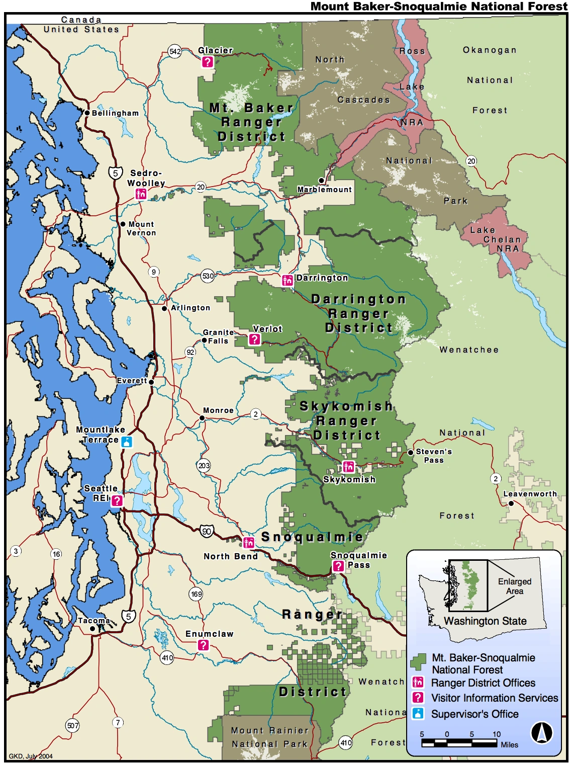
The Mount Baker-Snoqualmie National Forest covers (in descending order of forestland area) portions of Snohomish, Whatcom, Skagit, King, Pierce, and Kittitas counties. It has a total area of 1,724,229 acres (6,978 km2). The forest consists of four ranger districts. The following are listed geographically from north to south: the Mount Baker District has two ranger stations located in Glacier and Sedro-Woolley; the Darrington Ranger District has two ranger stations located in Darrington and Verlot; the Skykomish Ranger District has one ranger station located in Skykomish; and the Snoqualmie Ranger District has two ranger stations located in North Bend and Enumclaw.
Together with the other central Puget Sound counties, 62% (3.63 million people) of the state's population lives within a 70-mile (110 km) drive of the forest. Another 1.5 million in the Vancouver metropolitan area are also within easy reach of the northern part of the forest. The large population factor, coupled with easy road access, makes the Mount Baker-Snoqualmie National Forest the second most visited national forest in the country.
Conservation[]
The north and east portions of the forest are exceptionally rugged and scenic. In 1968, part of the forest was transferred to the National Park Service to be within North Cascades National Park. A 1993 Forest Service study estimated that the extent of old growth in the forest was 643,500 acres (260,400 ha). In addition, Congressional action since 1964 has established wilderness areas, which comprise 827,101 acres (3,347 km2)—almost half of the forest's area. These pristine areas provide clean water, solitude, and permanent protection to old-growth forests across 42% of the Mount Baker-Snoqualmie National Forest.
Congress also established the Skagit Wild and Scenic River System in 1978. Its 125 miles (201 km) of rivers on the Skagit, Cascade, Sauk, and Suiattle rivers provide important wildlife habitat and recreation. The Skagit River System is home to one of the largest winter populations of bald eagles in the United States.
The Mount Baker-Snoqualmie National Forest encompasses much of the North Cascades ecoregion, a Level III North American Ecoregion.