Lind is a town in Adams County, Washington. The population was 582 at the 2000 census.
History[]
Lind was first settled in 1888 on a relatively barren area along the Northern Pacific Railway's main line by Dugal and James Neilson. The sight had previously been selected in 1881 for a station (an old boxcar) and section house and was named Lind by the railroad although the exact origin of that name has been lost. In the autumn of 1888 the Neilson Brothers built the first Lind residence and two years later they built and stocked a store and resumed postal service which until then had been processed in Ritzville and tossed off in town by passing trains. James Neilson became the first postmaster. The first school opened in 1889 with six students in attendance. The Neilson Brothers platted the town site on June 7, 1890 which consisted of only four square blocks. The Panic of 1893 would shave off any further development of the townsite until the turn of the century.
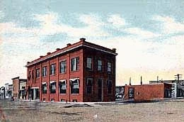
Downtown Lind, 1910.
By 1899 the panic was starting to wear off and the high quality of the local wheat crop was growing in demand. Lind began to expand in size. A new post office and saloon were built and a lumber yard was started and by the end of the year, the population was nearing 100. By the end of 1901, several brick buildings were being constructed for a bank and other stores and hundreds of temporary dwellings were constructed by settlers. A new school and three churches were built. Between 1898 and 1903, Lind grew immensely to a population of about 600 and saw the opening of many more stores, restaurants, a bank, real estate offices and a newspaper, The Lind Leader. Lind was incorporated on January 26, 1902. Dugal Neilson was elected mayor while his brother James was elected treasurer.

Downtown Lind 2010.
The Milwaukee Road would later lay its tracks through the south side of town, which is now the John Wayne Pioneer Trail. When the Neilson brothers platted the townsite of Lind, they named all of the north to south streets to eventually spell out their surname. The town only grew large enough to spell "Neilso" .
Geography[]
Lind is near the geographical center of Adams County, Washington. It is situated within the shallow Lind Coulee, which forms part of the border between a rich agricultural region and the Channeled Scablands and just east of where the Paha and McElroy Coulees branch off to the north. Lind is located 5 miles west of Highway 395 where it intersects with Lind - Ralston and Lind - Kahlotus road, officially known as SR 21, in an area known as East Lind on maps, located at the base of the Paha Coulee. from the east, SR 21 passes through the center of town by becoming East 2nd Avenue then turning left on to North I Street then right onto North 1st Street. As the highway turns north, Lind - Hatton and Lind - Warden Roads branch off to the west.
According to the United States Census Bureau, the town has a total area of 1.0 square miles (2.7 km²), all of it land.
Climate[]
Lind, WA climate is warm during summer when temperatures tend to be in the 70's and very cold during winter when temperatures tend to be in the 30's.
The warmest month of the year is July with an average maximum temperature of 87.90 degrees Fahrenheit, while the coldest month of the year is January with an average minimum temperature of 23.40 degrees Fahrenheit.
Temperature variations between night and day tend to be relatively big during summer with a difference that can reach 34 degrees Fahrenheit, and fairly limited during winter with an average difference of 14 degrees Fahrenheit.
The annual average precipitation at Lind is 9.96 Inches. Rainfall in is fairly evenly distributed throughout the year. The wettest month of the year is November with an average rainfall of 1.32 Inches.
Culture[]

Downtown Lind.
Lind is the home of the Combine Demolition Derby held annually in June. It has received much publicity over the past couple years when it was featured in Playboy's 50th Year Anniversary Special Edition issue. It has also been featured on Country Music Television (CMT). Lind also has thousands of wheat fields. About more than half are owned by Russian-German Mennonite and Hutterites farmers.
Infrastructure[]
Health[]
East Adams Rural Hospital is located 11 miles from Lind, in Ritzville.
Crime[]
The Adams County Sheriff's Office serves Lind from their office in Ritzville or Othello.
Transportation[]
Lind has the Lind Airport.