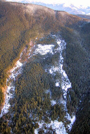
Swift Creek landslide from above.
Asbestos laden sediment originating from the landslide has generated much concern in this area. Asbestos is a known carcinogen. EPA sampling has documented asbestos in sediments in Swift Creek and in downstream Sumas River. Average asbestos levels in Swift Creek dredged material exceed the level that, in construction materials, triggers worker safety requirements and material handling and disposal regulations.
The Swift Creek Landslide is thought to be a smaller reactivation of an older and larger landslide in that area; perhaps an earthquake set the older, then static landslide into motion. Sumas Mountain had not been logged as of 1924, but it is speculated that the 1930s was an unusually wet decade, which also helped spark volitlity in the area of the landslide.
In August 2006, EPA completed a report on activity-based sampling (ABS) for Swift Creek dredged materials. The ABS measures the amount of asbestos in the breathing zone of personnel (with respiratory protection) performing routine activities, such as raking, running or biking, and digging/loading. Using these data, EPA estimated cancer risks for adults and children doing the same or similar activities for a given duration and frequency. These risks were, in some cases, greater than 1 in 10,000, a level considered by many health agencies to warrant concern and regulatory action.
In 2008, EPA collected samples outside some homes where residents had used Swift Creek dredged material to make driveways or pathways. Asbestos levels of up to 6 percent were measured. In September 2008, Whatcom County Health Department and the Washington Department of Health jointly issued a health advisory regarding Swift Creek.
In 2009, during heavy rains in January, the Sumas River flooded, leaving sediments behind after the floodwaters passed. EPA sampled upland flood deposits, streamside sediments, and water at 14 locations. Sediments contained up to 27% asbestos, and measurements of asbestos in surface water exceeded federal drinking water standards.
That July, Whatcom County Health Department and the Washington Department of Health updated their health advisory to include the northern part of the Sumas River.
Dynamics[]
This landslide is roughly half a kilometer in width, and 1.5 kilometers long. The depth of the landslide is approximately 100 meters. The velocity of the landslide varies, but the fastest moving part is at the toe, which moves upwards of 10 meters annually.
