Tacoma is located the Pacific Northwest region of the United States. Tacoma is a major port city and the third largest city in the State of Washington. The encompassing Seattle-Tacoma-Bellevue metropolitan statistical area is the 15th largest in the United States, and the largest in the northwestern United States. The city is on Washington's Puget Sound, 32 miles southwest of Seattle, 31 miles northeast of the state capital, Olympia, and 58 miles northwest of Mount Rainier National Park. Tacoma is the Puget Sound's second largest city, and the third largest city in Washington. Tacoma is the Pierce County seat. The 2018 population estimate is 209,100. The 2020 census population was 219,346, making it the third most populated city in Washington.
History
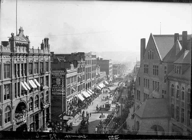
Tacoma's downtown, 1893.
The Tacoma area's original inhabitants, the Puyallup and Nisqually lived here for centuries before European explorers arrived. They called today's Mount Rainier "Tacobet," which means "Mother of Waters." Europeans transliterated the native name into "Tahoma," and then "Tacoma."
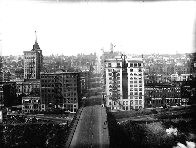
Downtown Tacoma in 1916, from across the Murray Morgan Street Bridge.
Captain George Vacouver was the first European to reach Puget Sound, arriving in 1792 and naming the body of water after Peter Puget, one of his officers. In 1833, Hudson's Bay Company built Fort Nisqually a few miles south of today's Tacoma. By the 1850s, settlers began to arrive, and Nicholas Delin built a cabin and sawmill along the waterfront in 1852, on the site of modern Tacoma. In 1868, the Northern Pacific Railroad chose Tacoma as its western terminus.
After the railroad arrived in 1883, Tacoma grew rapidly, the city was incorporated in 1875, and by 1892, 50,000 people lived here, but it was eclipsed when the Klondike gold rush turned nearby Seattle into a boom town.
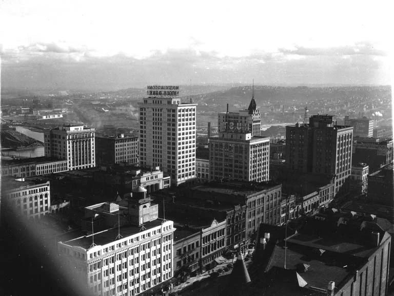
Downtown Tacoma in 1938.
In the early twentieth century, Weyerhaeuser Timber Company took a major role in Tacoma's economy, and in 1918, Tacoma became an official U. S. Port of Entry, the first step toward Tacoma's status as the six-largest container port in North America. By the 1930s, Tacoma may have been best known for the "Aroma of Tacoma" because of the malodorous emissions from the local paper manufacturing plants, but by the 1990s, the problem had been largely solved.
Geography
Tacoma is at 47°14′29″N 122°27′34″W (47.241371, -122.459389). Its elevation is 38 feet above sea level.. According to the United States Census Bureau, the city has an area of 62.6 square miles (2009). 50.1 square miles (129.8 km2) of it is land and 12.5 square miles (32.4 km2) of it (20.01%) is water. Situated on Commencement Bay, an inlet of Puget Sound, Tacoma lies at the foot of Mt. Rainier in the Puyallup River valley, bordered by mountains. It is about 36 miles south of Seattle. The city is near several military installations, including Fort Lewis and McChord Air Force Base.
Surrounding municipalities
To the northwest of Tacoma is Gig Harbor, while north is Vashon Island. To the northeast is Federal Way. Fox Island is directly east with Fife and Milton to the east. Lakewood is southwest of Tacoma, and Parkland to the south. Puyallup is to the southeast.
Districts and their Neighborhoods
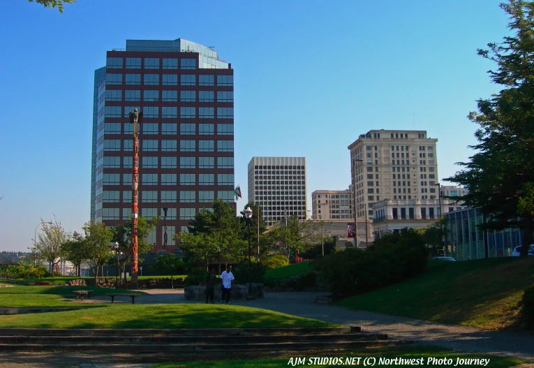
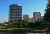
Tacoma from Fireman's Park in downtown. AJM STUDIOS Northwest Photo Journey photo.
Central Tacoma
- Hilltop (Part of Downtown)
- Delong Park
- The Wedge
- The McCarver Neighborhood (Part of New Tacoma and Downtown)
- Bryant
New Tacoma
- Downtown Tacoma
- Saint Helens Neighborhood
- Theater District
- Central Business District
- Warehouse/Brewery District
- Foss Waterway
- The McCarver Neighborhood
- Stadium District
- Dome District
Nalley Valley
Port of Tacoma
East Tacoma
- McKinley Hill
- Salishan
- Hillsdale
- Swan Creek
- Strawberry Hill
North Tacoma
- North Slope
- Old Tacoma
- Proctor District
- Prospect Hill
- Ruston Way
- Skyline
- Stadium District
- Westgate
- Yakima Hill
Northeast Tacoma
- Browns Point
- Crescent Heights
South End
- Fern Hill
- Larchmont
- Lincoln International District
- Stewart Heights
- Wapato
South Tacoma
- Edison
- Manitou
- Oakland / Madrona
- South Park
- Tacoma Mall
West Tacoma
- Highlands
- Narrows
- Titlow
- Salmon Beach
- Westgate
Landmarks
Tacoma has many major landmarks including the Tacoma Dome, Union Station, the Tacoma Narrows Bridge, numerous churches, and districts within the city.
Climate
The climate is quite mild throughout the year. Although the area has the reputation of being rainy, Tacoma. Most of the precipitation falls in the winter, when snow blankets the mountains. Tacoma and the South Puget Sound tends to be a few degree's warmer then Seattle and several degrees warmer then Everett from Spring to Fall.
Tacoma's climate overall is warm during summer when temperatures tend to be in the 70's and 80's. It cools down during winter when temperatures tend to be in the 40's.
The warmest month of the year is August with an average maximum temperature of 76.60 degrees Fahrenheit, while the coldest month of the year is January with an average minimum temperature of 35.10 degrees Fahrenheit.
Average temperatures are 40.8°F in January, and 65.4°F in July. The annual average temperature is 53.1°F. The average annual precipitation is 39.2 inches.
Temperature variations between night and day tend to be moderate during summer with a difference that can reach 21 degrees Fahrenheit, and fairly limited during winter with an average difference of 13 degrees Fahrenheit.
The annual average precipitation at Tacoma is 38.95 Inches. Winter months tend to be wetter than summer months. The wettest month of the year is November with an average rainfall of 6.10 Inches.
Culture
Media
Newspapers
Tacoma Daily Index
The Business Examiner
The News Tribune
Tacoma Weekly
Weekly Volcano
Sports
Baseball: PCL: Tacoma Rainiers
Basketball: IBL: Tacoma Jazz
Soccer: PDL: Tacoma Tide
Infrastructure
Health systems
Tacoma has four major hospitals. Mary Bridge Children's Hospital, Puget Sound Behavioral Health Center, Saint Joseph Medical Center, Tacoma General Allenmore Hospital, and Western State Hospital.
Transportation
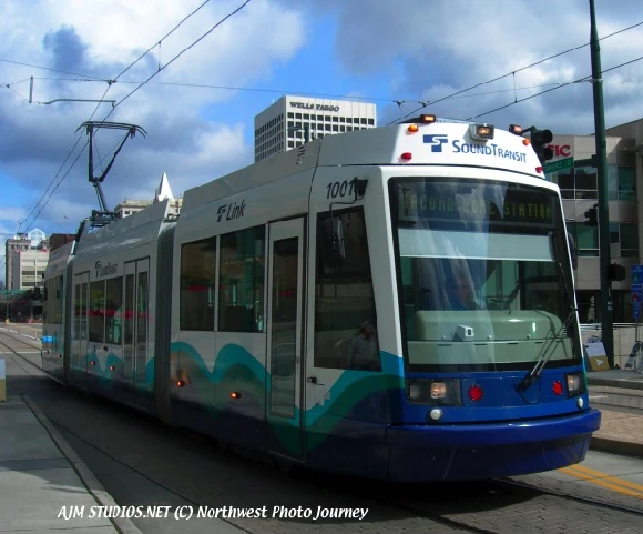
Tacoma Link in downtown. AJM STUDIOS Northwest Photo Journey photo.
Tacoma's alternative transportation services include buses, commuter rail, light rail, and ferries. Public bus service is provided by Pierce Transit, which serves Tacoma and Pierce County. Pierce Transit operates a total of 55 bus routes, using mostly buses powered by compressed natural gas. Most bus service operates at 30-minute frequencies on weekdays, some routes once an hour, while three heavily-ridden "trunk" routes are served every 15 minutes on weekdays and every half hour on weekends.
Sound Transit, the regional transit authority, provides weekday peak-direction Sounder Commuter Rail service and express bus service to and from Seattle seven days a week. (Service to and from Olympia is serviced by Pierce and Intercity Transit.) Sound Transit has also established Tacoma Link light rail, a 1.6 mile long free electric streetcar line linking Tacoma Dome Station with the University of Washington, Tacoma, Tacoma's Museum District, and the Theater District. Expansion of the city's rail transit system (either in the form of electric streetcars or light rail) is under consideration by the city of Tacoma and Pierce Transit, and is supported by a local grassroots organization, Tacoma Streetcar. The Washington State Ferries system, which has a dock at Point Defiance, provides ferry access to Tahlequah at the southern tip of Vashon Island, typically on the ferry MV Rhododendron. Greyhound service is also accessible via Tacoma Dome Station. An Amtrak station one block east on Puyallup Avenue serves the Cascades and Coast Starlight routes.